100% FREE ONLINE DATING
| Topic: ALASKA WILDFIRES - 6.500+ burned | |
|---|---|

|
|
|
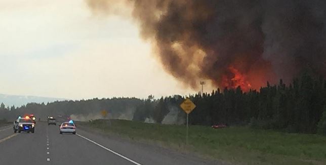
Alaska wildfires destroy dozens of homes, menace highway JUNEAU, Alaska | By Steve Quinn Tue Jun 16, 2015 8:24am EDT Two fast-spreading Alaska wildfires have forced a series of evacuations, destroyed up to 45 homes and forced authorities to restrict traffic on a major highway connecting two of the state's largest cities, state officials said on Monday. As many as 200 firefighters have been battling a 6,500-acre fire about 40 miles (64 km) north of Anchorage since Sunday afternoon. About 137 miles (220km) south of Anchorage, crews are fighting a much smaller, but equally dangerous blaze that threatens nearly 200 homes. Additional specially trained firefighting teams from the lower 48 states and Canada were scheduled to arrive on Monday night and begin assisting on Tuesday, Alaska Forestry Division spokesman Sam Harrel said. Crews have been battling the fires on the ground and from the air, with help from the three Alaska National Guard Blackhawk helicopters, according to state reports. Harrel said the larger fire was ignited by human activity but the specific cause is being investigated. Dry and warm weather accelerated the blaze, he said. It started on Sunday afternoon near Willow, where the Iditarod, Alaska's famed sled-dog race, typically kicks off. It initially covered about two acres, but within 11 hours had engulfed 6,500 acres, according to the forestry division. Harrel said flames quickly jumped from one 30- to 40-foot spruce tree to the next, forcing a temporary closure of the Parks Highway, which links Anchorage in the state's south central region to Fairbanks in Alaska's eastern interior. http://www.reuters.com/article/2015/06/16/us-usa-wildfires-alaska-idUSKBN0OV2IK20150616 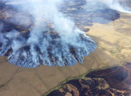

************************* Saying prayers & special thoughts for all who are battling this horrid event! 2nd warmest - dry year on record = Anchorage Alaska |
|
|
|
|
|
|
Edited by
2OLD2MESSAROUND
on
Tue 06/16/15 09:30 AM
|
|
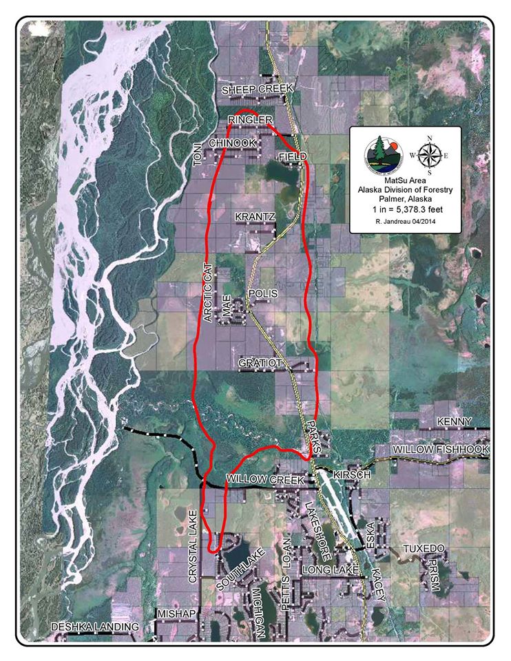
Map of Area that burnt last year - 2014
Funny River burning this year 2015 
WEATHER PATTERN MAP MAY - 2015 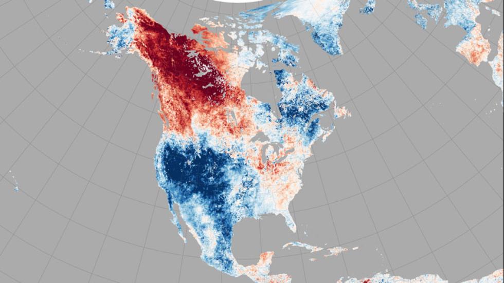
|
|
|
|
|

|
|
|
Is that red..drought?
|
|
|
|
|

|
|

|
|
|
|
|

|
|
|
Is that red..drought? Can't be, California would be bright red too. |
|
|
|
|
|
|
|
|
Is that red..drought? Can't be, California would be bright red too. Mmm, must be dry weather then? |
|
|
|
|
|
|
|
|
Soufiehere asked >>>
Is that red..drought? alleoops posted >>>
Can't be, California would be bright red too. Soufiehere stated >>>
Mmm, must be dry weather then? No...not drought but it is a thermal/temp map; notates the extreme temps for regions May 2015. We've had cooler temps in central Ks then Anchorage Alaska has had for the past 2 years. Something odd/off kilter going on! |
|
|
|
|

|
|
|
Actually we are in a type of drought. The Red you see in the map is the red zones for high alert for fires...We have had almost nil for snowfall etc. We are bone dry and we are getting lightening. All it is going to take is one strike to be a disaster.
The fire they are calling Sockeye is really close to where I live, I mean as a crow flies about 20 miles away give or take.What is helping this one right now the winds have died down. IF we get the winds they keep predicting there will be no stopping it. Til it runs out of fuel. The really sad thing about this is all the people that are now homeless up here so many in that area live a truly subsistence lifestyle if they make 10K over what they get for dividends would be a lot. They have no money left over for Home owners insurance. Most of the Fire departments are totally volunteer in those small rural areas,so insurance is out of sight so they go with out and quite honestly some of the dry cabins were built no where to what most people would think of Code that is the Alaskan way. I don't know as much about the Card street fire and what is happening down there that one is over 125 Miles away from us.. Kind of wrapped up with this one. Where I live on Friday I registered 57 degrees here on my deck, Sunday the same place registered 87. Yesterday was 89 today 88.With no rain in sight for at least 2 weeks not a good scenario... Firefighters are coming in from BC, lower 48 all points inbetween.. So this time Yeah Alaska could use some prayers. They are comparing this to a fire from way back that we lost whole communities.. or what would be called subdivision down south... |
|
|
|
|
|
|
|
|
From my original post >>>
Saying prayers & special thoughts for all who are battling this horrid event! 2nd warmest - dry year on record = Anchorage Alaska My high school buddy sent me photo's of them trucking snow in for the Iditarod dog sled race {2nd year that they had to do that as well}...she's been in Anchorage since 1973 - works in the Hwy Patrol. |
|
|
|
|
|
|
|
|
From my original post >>> Saying prayers & special thoughts for all who are battling this horrid event! 2nd warmest - dry year on record = Anchorage Alaska My high school buddy sent me photo's of them trucking snow in for the Iditarod dog sled race {2nd year that they had to do that as well}...she's been in Anchorage since 1973 - works in the Hwy Patrol. I meant that in general terms. |
|
|
|
|
|
|
|
|
2old2 posted
From my original post >>> Saying prayers & special thoughts for all who are battling this horrid event! 2nd warmest - dry year on record = Anchorage Alaska My high school buddy sent me photo's of them trucking snow in for the Iditarod dog sled race {2nd year that they had to do that as well}...she's been in Anchorage since 1973 - works in the Hwy Patrol. SitkaRains stated >>>
I meant that in general terms. OOOOH - No harm/No Foul; but my concern about you and your location was why I started this thread/topic; I was worried about you and your area! 
I've been looking at maps because a good buddy is working up at Denali National Park and has a 'wee cabin' - very secluded and rural set back in the wooded area. |
|
|
|
|
|
|
|
|
I've been looking at maps because a good buddy is working up at Denali National Park and has a 'wee cabin' - very secluded and rural set back in the wooded area.
Well that is way way north, they should be fine...unless a burn starts up there, then all bets are off. This one has been traveling south... |
|
|
|
|
|
|
|
|
2old2 stated >>>
I've been looking at maps because a good buddy is working up at Denali National Park and has a 'wee cabin' - very secluded and rural set back in the wooded area. SitkaRains posted >>>
Well that is way way north, they should be fine...unless a burn starts up there, then all bets are off. This one has been traveling south... Noooo, her 'wee little cabin' in the woods is outside of the city limits of Fairfax, AK --- her nearest neighbor is like 25 miles away! Do you know if that region is still SAFE??? She's been on FB asking for help - trying to contact her nearest neighbor but they aren't answering their land line! |
|
|
|
|
|
|
|
|
Just tried to message you.. but your filters are in place I can so please message me.. about Fairfax...
|
|
|
|
|
|
|
|
|
SitkaRains posted >>>
Just tried to message you.. but your filters are in place I can so please message me.. about Fairfax... I sent you a 'Friends' request; just found that option --- had no idea how or where that was! Lordy!!! |
|
|
|
|

|
|
|
Wow I hope they get control soon... The king fire last year in California started 150 yards from my house and was named after my road of king of the mountain rd ..
it burned for over 3 weeks out of control and went 97.000 aches Oh and I'm the king as I have lived up there for the longest 29 years |
|
|
|
|
|
|
|
|
Wow I hope they get control soon... The king fire last year in California started 150 yards from my house and was named after my road of king of the mountain rd .. it burned for over 3 weeks out of control and went 97.000 aches Oh and I'm the king as I have lived up there for the longest 29 years Wow, too close. How do most of the fires start? Lightning? |
|
|
|
|

|
Edited by
ridewytepony
on
Wed 06/17/15 11:19 AM
|
|
Wow I hope they get control soon... The king fire last year in California started 150 yards from my house and was named after my road of king of the mountain rd .. it burned for over 3 weeks out of control and went 97.000 aches Oh and I'm the king as I have lived up there for the longest 29 years Wow, too close. How do most of the fires start? Lightning? Yes,in BC its over 50%. Lightning has been known to travel 15km (9 miles) from the storm cell,so quite often it makes contact with dry ground. We use a Lightning detector system here that covers/detects 90% at this time.Its Real time and the coordinates are sent to the Forest Service almost instantly. |
|
|
|
|
|
|
|
|
ZZZippy stated >>>
Wow I hope they get control soon... The king fire last year in California started 150 yards from my house and was named after my road of king of the mountain rd .. it burned for over 3 weeks out of control and went 97.000 aches Oh and I'm the king as I have lived up there for the longest 29 years AlleOops posted >>>
Wow, too close. How do most of the fires start? Lightning? ridewytepony replied >>>
Yes,in BC its over 50%. Lightning has been known to travel 15km (9 miles) from the storm cell,so quite often it makes contact with dry ground. We use a Lightning detector system here that covers/detects 90% at this time.Its Real time and the coordinates are sent to the Forest Service almost instantly. California mostly careless camp fires and a huge increase in ARSON; even a couple of volunteer fire fighters were finally caught doing ARSON FIRES! But yes, up in the wilderness of our forest area's it's often lightening striking trees - power travels down the length of those tall giants and blows them up - causes internal fires that will smolder for days - and then all the dry underbrush fuels that fire and the strong winds propels it along! Most of our schools are using those 'Lightening Meters' while there are outside events: soccer clubs/football/track & field events and thorough bred race tracks and dog tracks have them! |
|
|
|
|


