100% FREE ONLINE DATING
sponsored links
| Topic: Stay Safe Southern U.S. Minglers (weather related) | |
|---|---|

|
|
|
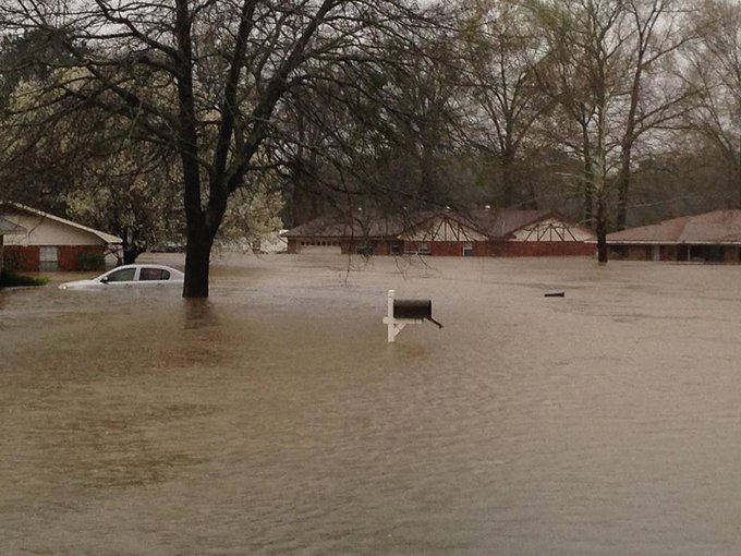
"" Dangerous Flash Flooding, Along With Severe
Thunderstorms, Tornadoes in the South (FORECAST) The threat of torrential rain is kicking into high gear, and will persist in parts of the South for the next several days, where over a foot of rain may trigger dangerous, life-threatening flash flooding. Among the cities that should be alert for potentially major flash flooding the next few days are Dallas-Fort Worth, Houston, San Antonio, Austin, Shreveport, Louisiana and Little Rock, Arkansas, and New Orleans. The flooding already kicked in Monday night, flash flooding west of Ft. Worth, Texas, swamped homes and forced water rescues If that wasn't enough, severe thunderstorms and at least some tornadoes, are expected through at least Wednesday in some of the same parts of the southern Plains, Lower Mississippi Valley and Gulf Coast. NOAA's National Weather Service has issued a tornado watch for portions of East Texas, far southeastern Oklahoma, southwestern Arkansas and western Louisiana until 6 p.m. CST. The watch includes the cities of Houston, Shreveport and Texarkana. An EF1 tornado caused damage near Cool, Texas Monday evening and an apparent tornado touched down near Tolar, Texas, southwest of Ft. Worth Tuesday morning. An EF1 tornado also left a narrow path of damage in Stephenville, Texas early Tuesday. A squall line then surged through Ft. Worth packing a 66 mph gust at the Ft. Worth Meacham Airport and a gust to 72 mph at Interstate 820 and Blue Mound Road. Below is a breakdown of the flooding and severe weather threats the next several days followed by an explanation of what is causing the stormy weather. Flooding Threat The National Weather Service has issued flash flood watches parts of East Texas, southeast Oklahoma, most of Arkansas, western Lousiana, southern Missouri and southwestern Illinois. A "cutoff" low sits and spins over Mexico and Texas, keeping a stream of moisture pointed at the south-central states. Periods of rain and thunderstorms will take aim on parts of the southern Plains eastward to the Mississippi River Valley, northern Gulf Coast, Ohio Valley and Tennessee Valley. Persistent, slow-moving bands of rain and thunderstorms may ultimately drop a foot of rain or more in some of these areas, triggering dangerous, life-threatening, destructive flash flooding and river flooding. The area at highest risk includes parts of east and north Texas, southeast Oklahoma, Arkansas, western and northern Louisiana and southern Missouri. Potential cities: Dallas | Houston | Shreveport | Little Rock The flood threat may persist in parts of the Lower Mississippi Valley and Deep South into Friday."" https://weather.com/storms/tornado/news/severe-flood-forecast-march-7-12-2016 |
|
|
|
|

|
|
|
Praying for your safety.
Keep safe |
|
|
|
|

|
|
|
We had some flash flooding high winds and tornado's spotted west of me this morning.. I'm in the NW side of Ft.Worth...
Pretty wild here all the sirens were going off this morning around 8am about the time I was walking out the door to head to work... Got 8 blocks and had to turn around and go back home. It was raining and the wind blowing so hard street lights were horizontal and signs were bent over touching the ground.. my car was rocking and I was not dancing to the music... 
Got home only had about 5ft to get onto my covered porch. Could not hardly open my car door it had started hailing a little as well.. Got on the porch and was drenched... Could not see the tree 5ft from the windows due to it raining so hard and wind blowing so much.. Had to dry off and change clothes down to my shoes due to I was soaked... lasted about 30 minutes and it was gone as fast as it came in.. pretty wild for sure... Lots of tree limbs down Many areas west of me got it pretty hard.. and have more coming... Hood county got it really hard in Tolar~~ Mineral Wells many areas flooded.. Denton was hit pretty hard as well as Frisco.. every where it seemed to hit it tore up something... 
All I can say those that are in it's path stay safe...... The Military Base recorded around 65 mile a hour wind which is like less then 5 miles south of my house.. It is so close I can hear the music from the base in the mornings... 
|
|
|
|
|
|
|
|
|
Praying for your safety. Keep safe 
And dang Ms TxGal...I knew yall were gettin bad weather but didnt think it was THAT bad...gonna be a week long event it looks like....get the boat ready...and the paddles 
|
|
|
|
|
|
|
|
|
Good LAWD at the rain...heavy rain here since abt 3 pm yesterday with no let up. 100% chance today and tonight and still more forecasted through Saturday.
About 45 min west of me, 14 inches has fallen. We're gonna need a bigger boat!

^^^^^^ All 45 min west of me. Only flooding in low lying areas here so far. Had a damn limb fall on my roof last night knocking a hole in it. Got soaked making a quick temp patch....3 more days of this $hit. |
|
|
|
|
|
|
|

Interstate 20, near where Bonnie and Clyde where killed, now closed.... |
|
|
|
|
|
|
|
|
Beware of the sharks Txgal.
|
|
|
|
|

|
|
|
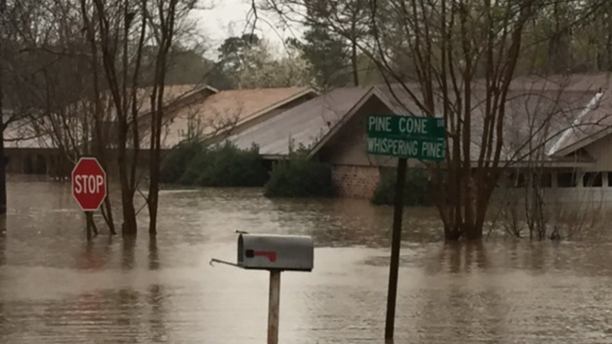
Life-Threatening Flooding and Tornadoes Hit South
(90 PHOTOS) 
Mar 9 2016 04:00 PM EST weather.com A multi-day round of severe weather and flooding is bearing down on the South, tipping communities into a state of emergency. At least two people have died. Louisiana Gov. John Bel Edwards declared a state of emergency for several parishes and dispatched the National Guard. In Shreveport, nearly a half-foot of rain fell Tuesday, making it one of the three rainiest winter days on record for the city. Dozens of homes had to be evacuated in nearby towns, and water rescues were performed to remove stranded residents. The deluge also hit eastern Texas and much of Arkansas, and meteorologists expected the potentially life-threatening rains to continue through at least Thursday. Earlier this week, the system spawned an EF1 tornado that ripped apart homes in Cool, Texas. Two additional EF1 tornadoes were confirmed on Tuesday, one of which destroyed multiple mobile homes and injured at least two people near Tolar. Those storms eventually moved into the Dallas-Fort Worth area, leaving more damage and even forcing a ground stop at DFW International Airport. At the top of this page, we will be collecting images from both sides of this storm system, and we urge you to check back frequently for the latest photos. http://weather.com/slideshows/news/severe-weather-flooding-south-photos/ * Unbelievable! * |
|
|
|
|
|
|
|
|
* Unbelievable! * My local news reported that our local rainfall total record was broken today...11.9 inches in a 24 hr period.
Several neighborhoods are flooded, roads closed, schools closed....its like a snow day without, well, the snow
Seriously, it sucks....still pouring but may get a break Thursday night. |
|
|
|
|
|
|
Edited by
SassyEuro2
on
Wed 03/09/16 05:45 PM
|
|
* Unbelievable! * My local news reported that our local rainfall total record was broken today...11.9 inches in a 24 hr period.
Several neighborhoods are flooded, roads closed, schools closed....its like a snow day without, well, the snow
Seriously, it sucks....still pouring but may get a break Thursday night. In 24 hours !? Damn!!! How many days straight has it rained? |
|
|
|
|
|
|
|
|
* Unbelievable! * My local news reported that our local rainfall total record was broken today...11.9 inches in a 24 hr period.
Several neighborhoods are flooded, roads closed, schools closed....its like a snow day without, well, the snow
Seriously, it sucks....still pouring but may get a break Thursday night. In 24 hours !? Damn!!! How many days straight has it rained? |
|
|
|
|

|
|
|
you on high ground? hope ya don't live on a river
and have a sump pump in basement if needed |
|
|
|
|
|
|
|
|
* Unbelievable! * My local news reported that our local rainfall total record was broken today...11.9 inches in a 24 hr period.
Several neighborhoods are flooded, roads closed, schools closed....its like a snow day without, well, the snow
Seriously, it sucks....still pouring but may get a break Thursday night. In 24 hours !? Damn!!! How many days straight has it rained? How many times has your state declared a ' State Of Emergency', since Hurricane Katrina? |
|
|
|
|
|
|
|
|
you on high ground? hope ya don't live on a river and have a sump pump in basement if needed How many times has your state declared a '
Alot.....but its usually South Louisiana...here it is a lil unusual.
State Of Emergency', since Hurricane Katrina? |
|
|
|
|
|
|
|
|
And speaking of South LA....
"" ORLEANS: ...FLASH FLOOD WATCH REMAINS IN EFFECT FROM THURSDAY MORNING THROUGH SATURDAY MORNING ... THE FLASH FLOOD WATCH CONTINUES FOR * PORTIONS OF SOUTHEAST LOUISIANA AND MISSISSIPPI ...INCLUDING THE FOLLOWING AREAS ...IN SOUTHEAST LOUISIANA ...ASCENSION ... ASSUMPTION ...EAST BATON ROUGE ...EAST FELICIANA ...IBERVILLE ... LIVINGSTON ...LOWER JEFFERSON ...LOWER LAFOURCHE ...LOWER PLAQUEMINES ...LOWER ST. BERNARD ...LOWER TERREBONNE ...NORTHERN TANGIPAHOA ...ORLEANS ...POINTE COUPEE ...SOUTHERN TANGIPAHOA ... ST. CHARLES ...ST. HELENA ...ST. JAMES ...ST. JOHN THE BAPTIST ... ST. TAMMANY ...UPPER JEFFERSON ...UPPER LAFOURCHE ...UPPER PLAQUEMINES ...UPPER ST. BERNARD ...UPPER TERREBONNE ... WASHINGTON ...WEST BATON ROUGE AND WEST FELICIANA. IN MISSISSIPPI ...AMITE ...HANCOCK ...HARRISON ...JACKSON ...PEARL RIVER ...PIKE ...WALTHALL AND WILKINSON. * FROM THURSDAY MORNING THROUGH SATURDAY MORNING * RAINFALL ...6 TO 10 INCHES OF RAINFALL WITH LOCALLY HIGHER AMOUNTS IN EXCESS OF ONE FOOT THROUGH SATURDAY MORNING."" http://m.accuweather.com/en/us/new-orleans-la/70112/weather-warnings/348585 ....a foot of rain for NOLA isnt good. |
|
|
|
|
|
|
|
|
Thanks Rebel for sharing.
That's looks pretty bad I hope you are all safe on high ground |
|
|
|
|
|
|
|
|
Thanks Rebel for sharing. That's looks pretty bad I hope you are all safe on high ground 
|
|
|
|
|
|
|
|
|
YESTERDAY:
FLASH FLOODS IN LOUISIANA, 1,000'S EVACUATED, 3 DEAD http://youtu.be/Q6mGqacBTKE/ 01:22 - RT News 'National Weather service called it ' historic ' flash flooding in the town of Haughton Louisiana. State of emergency has been declared. Millions could be affected. ------------ Pine Bluff, AR Flash Flooding - 3/9/2016 http://youtu.be/7EDJny3wUQo/ 02:42 - Storm Chasers ---------------- Watch: Dramatic flood damage in Louisiana: http://youtu.be/cuD8SrvysGY/ 02:49 - CBSN -------- TODAY: More Rain for an Already Soaked Northern Louisiana: http://youtu.be/ZbjX6OtumGU/ 04:00 - OnLine24 News Rain expected to last until Friday afternoon. The National Guard has been sent in to help. |
|
|
|
|
|
|
|
|
Our local airport has measured rainfall totals at 16.45 inches as of 10 hrs ago.
The National Guard performed over 200 rescues last night here in my parish. Still raining but its seems to have lightened up a little bit....but rain is supposed to stay all day today, tonight, and into Friday. |
|
|
|
|

|
|

|
|
|
|
|